
 Continue with onX Maps
 Continue with Facebook


 Difficult

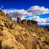
“This bench-cut, flow trail mixes technical "g"-in/out chutes with a few tight, rock pinches. ”


5.1
Miles8.3
KMSingletrack
 Difficult
Local Club: Colorado River Area Trail Alliance
Land Manager: BLM Arizona - Kingman Field Office
 Beale Banger
22.2 mi 35.8 km • 2,783' Up 848.15 m Up • 2,787' Down 849.36 m Down

 Monolith Gardens
9.4 mi 15.2 km • 748' Up 227.94 m Up • 747' Down 227.83 m Down
 Kingman, AZ
2019 Route 66 Rattler Race
Kingman, AZ
2019 Route 66 Rattler Race
15.8 mi 25.5 km • 895' Up 272.7 m Up • 895' Down 272.88 m Down
Kingman, AZ
Hualapai Mountains Gold King Mansion Ride
29.0 mi 46.6 km • 4,085' Up 1244.99 m Up • 4,084' Down 1244.71 m Down
Kingman, AZ
Big Wash Climb
21.3 mi 34.2 km • 2,949' Up 898.82 m Up • 2,953' Down 900.22 m Down


0 Comments