
 Continue with onX Maps
 Continue with Facebook


 Difficult

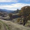
“An adventure on rugged isolated trail. ”


4.0
Miles6.4
KMSingletrack
 Difficult
Land Manager: Berryessa Snow Mountain National Monument (BSM-NM)
 Fiske to Foley Creek to Long Canyon
27.3 mi 43.9 km • 4,262' Up 1298.97 m Up • 4,266' Down 1300.4 m Down
 Fiske Creek Loop
17.2 mi 27.7 km • 2,870' Up 874.81 m Up • 2,870' Down 874.78 m Down
High Bridge to Cache Creek Ridge
12.8 mi 20.5 km • 1,724' Up 525.45 m Up • 1,719' Down 523.91 m Down
 Las Posadas Forest - Short Loop
3.5 mi 5.6 km • 472' Up 143.91 m Up • 472' Down 143.75 m Down
 Angwin, CA
Oat Hill Mine Trail
Angwin, CA
Oat Hill Mine Trail
16.6 mi 26.8 km • 2,678' Up 816.27 m Up • 2,677' Down 816 m Down
Calistoga, CA
Trione-Annadel State Park - Big Loop
16.7 mi 26.9 km • 1,830' Up 557.88 m Up • 1,839' Down 560.5 m Down
Santa Rosa, CA


0 Comments