
 Continue with onX Maps
 Continue with Facebook


 Intermediate/Difficult

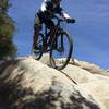
“A great ride with a variety of technical challenges, which are rideable depending on your skills. ”


1.5
Miles2.4
KMSingletrack
 Intermediate/Difficult
Local Club: Mount Wilson Bicycling Association
Land Manager: USFS - Angeles National Forest Office
 Winter Creek Loop
4.9 mi 7.9 km • 1,236' Up 376.75 m Up • 1,245' Down 379.49 m Down

 Sierra…, CA
 Mt. Wilson Shuttle
6.9 mi 11.1 km • 193' Up 58.73 m Up • 4,876' Down 1486.28 m Down
Eaton Saddle Downhill Shuttle
13.8 mi 22.2 km • 768' Up 234.15 m Up • 4,747' Down 1446.75 m Down
Altadena, CA
Ken Burton Loop
14.8 mi 23.7 km • 2,055' Up 626.5 m Up • 2,058' Down 627.35 m Down
Hillyer - Silver Moccasin Loop
13.3 mi 21.4 km • 1,649' Up 502.69 m Up • 1,639' Down 499.43 m Down
Monrovia, CA
Super Strawberry
25.5 mi 41.1 km • 2,639' Up 804.51 m Up • 5,130' Down 1563.76 m Down
Altadena, CA


0 Comments