Use onX Backcountry to explore the terrain in 3D, view recent satellite imagery, and more.
Now available in onX Backcountry Mobile apps!
For more information see this post.
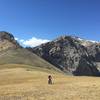
This trail starts a 1/2 mile from the Loristica campground. The trail begins at the end of a dead end logging road and you'll have scattered rolling pockets of aspen and fir for the first mile, then the terrain opens to sagebrush and grass with fir trees on the left. You'll climb to your first saddle and then drop into Big Creek where you'll find dense timber. Then you'll cross the head of Big Creek, and then start to switchback through rock and sagebrush.
The trail then climbs to a large high elevation plateau, which has a spectacular views of the Little Lost and the Big Mountain Range. You'll stay on the plateau for about a mile before dropping steeply into Hell Canyon. The trail is very difficult as you head towards the Shadow Lakes, but becomes more moderate after the lakes as you drop into the Long Lost drainage. The Shadow lakes are a short side trip and scramble.
Moderately steep. Uneven terrain with small rocks or roots.
Sizable rocks & roots. Steep sections.
Steep. Some technical terrain and limited alternate lines.
Very steep. Technical terrain with no alternate lines.
Difficulty Rating
Average from 1 vote:
Very Difficult
Your Rating
Virtual Tour of Long Lost-Wet Creek
We use cookies to improve your browsing experience, to show you
personalized content, and for statistical purposes. By continuing
to navigate our website, you accept our use of cookies. Read our
Privacy Policy to learn more.

 Continue with onX Maps
 Continue with Facebook


 Very Difficult


0 Comments