
 Continue with onX Maps
 Continue with Facebook


 Difficult

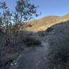
“Winds around the north side of Strawberry Peak. ”


5.0
Miles8.1
KMSingletrack
 Difficult
Local Club: Concerned Off-Road Bicyclists Association - CORBA
Land Manager: USFS - Angeles National Forest Office
 Strawberry Peak Loop
15.6 mi 25.0 km • 2,593' Up 790.29 m Up • 2,603' Down 793.49 m Down

 Altadena, CA
 Mt. Lukens from the Fire Station
15.0 mi 24.1 km • 2,843' Up 866.4 m Up • 2,842' Down 866.24 m Down
 Mt. Wilson Shuttle
6.9 mi 11.1 km • 193' Up 58.73 m Up • 4,876' Down 1486.28 m Down
 Haines Canyon Motorway - Blue Bug (Old Mt. Lukens Trail)
7.1 mi 11.4 km • 1,894' Up 577.35 m Up • 1,894' Down 577.39 m Down
Cherry Canyon
4.2 mi 6.8 km • 718' Up 218.7 m Up • 718' Down 218.7 m Down
Hillyer - Silver Moccasin Loop
13.3 mi 21.4 km • 1,649' Up 502.69 m Up • 1,639' Down 499.43 m Down
Monrovia, CA


3 Comments