
 Continue with onX Maps
 Continue with Facebook


 Intermediate/Difficult

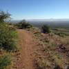
“A loop along the west side of the Franklin Mountains. ”


11.1
Miles17.9
KMSingletrack
 Intermediate/Difficult
Local Club: Borderland Mountain Bike Association (BMBA)
Dec 7, 2023: The first-ever weather station on the Franklin Mountains by the BMBA.
Oct 30, 2023: Borderland Mountain Bike Association Takes on the Chupacabras Mountain Bike Race in Mexico
Oct 3, 2023: Restoring Natural Beauty: BMBA and Volunteers Erase Graffiti from Lost Dog Trail
Land Manager: Texas Parks and Wildlife - Franklin Mountains State Park
 Sotol Loop
12.3 mi 19.8 km • 1,053' Up 320.98 m Up • 1,055' Down 321.51 m Down
 Westway, TX
El Paso Puzzler 50-Mile Endurance MTB Race
Westway, TX
El Paso Puzzler 50-Mile Endurance MTB Race
51.0 mi 82.1 km • 5,676' Up 1730.17 m Up • 5,666' Down 1726.85 m Down
Westway, TX
 El Paso Puzzler Mini Epic 15-Mile Race Loop
16.0 mi 25.7 km • 1,447' Up 441.15 m Up • 1,447' Down 441.06 m Down
 Westway, TX
El Paso Puzzler 50-Mile Endurance MTB Race
Westway, TX
El Paso Puzzler 50-Mile Endurance MTB Race
52.2 mi 84.1 km • 5,635' Up 1717.63 m Up • 5,633' Down 1716.97 m Down
Westway, TX
Palisades Canyon Loop
4.8 mi 7.8 km • 894' Up 272.62 m Up • 894' Down 272.59 m Down
 Arroyo Park Loop
1.8 mi 2.9 km • 129' Up 39.31 m Up • 129' Down 39.33 m Down


1 Comment