Dogs Leashed

E-Bikes
Unknown

Closed 24hrs for every fallen inch of rain
Description
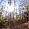
From the Reedy Creek parking area take a left on Riverside drive and look for a dirt-ish road immediately after the road crosses over the creek. This is both the entrance and exit point to the loop. I will describe the loop in the counterclockwise direction below.
Stay on the dirt road sized walking path that drops down along the creek until you see a large cement block with a manhole in the top of it (approximately 3' tall). A square pipe crosses the creek here and you ride across it (it's about 3' wide....and be careful, walk if necessary). The easiest access to ride onto the "bridge" is riding around the upstream side of the cement block and then riding across.
From here the trail is fairly straightforward. Continue up a climb, ride the trail skirting the parking lot, down a fun decent with some interesting whoop-dee's, continue up another climb until you reach a single lane paved walk way. Ride across this, down the stairs on the other side and up the brief climb. At the top of this climb you end up at the top of some stone stairs. From here ride the pathway that continues adjacent a chain link fence that encloses the
James River Park System "physical plant" (where they keep all of their stuff for maintaining the park). This will lead you to some more trail that continues up to a road with another paved walking trail crossing.
Cross the paved path and continue on the singletrack down to a bridge over Reedy creek (wooden 3' wide with hand railings). Cross this, the trail continues right from here. From here the trail is easier to follow for about a half mile with some side hill meanderings. Eventually you get a descent with a hairpin right turn. After this continue down across the creek and start the climb up right. The top of this climb appears to go straight, but take the left turn up hill here and continue through switchbacks and turns the remaining half mile to where we began.
Note, counter-clockwise is just the direction I prefer. In the last several years (2009 - present 8/10/13) the races in the area have used this section the other direction.
Contacts
Shared By:
Rob Tompkins

 Continue with onX Maps
 Continue with Facebook


 Intermediate


 Minor Issues


2 Comments