
 Continue with onX Maps
 Continue with Facebook


 Intermediate

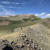
“This gravel road is the main access loop to the mountains north of Creede leading to several other gravel/4WD roads. ”


12.3
Miles19.8
KMDoubletrack
 Intermediate
Land Manager: USFS - Rio Grande National Forest Office
 Bristol Head
15.4 mi 24.7 km • 1,753' Up 534.39 m Up • 1,753' Down 534.39 m Down

 FSR 523/524
14.1 mi 22.7 km • 2,085' Up 635.4 m Up • 2,080' Down 633.89 m Down
 Cataract Ridge Backcountry
38.0 mi 61.2 km • 6,272' Up 1911.84 m Up • 6,619' Down 2017.32 m Down
 Jarosa Mesa Loop
18.6 mi 29.9 km • 2,128' Up 648.58 m Up • 2,105' Down 641.69 m Down
 Penitente Canyon Trails - Boot Mountain Loop
45.6 mi 73.4 km • 5,212' Up 1588.5 m Up • 5,219' Down 1590.89 m Down
Colorado Trail: The Entire MTB Route - IMBA EPIC
549.3 mi 884.0 km • 71,117' Up 21676.5 m Up • 69,664' Down 21233.6 m Down
Roxboro…, CO


0 Comments