This ride features a big climb or vehicle shuttle followed by a ripping backcountry singletrack descent through the alpine, and a rooty and rocky finish through the woods back to Breckenridge.
This ride starts at the Beaver Run parking lot in Breckenridge and climbs the
Peak 9 Access Road to the Wheeler Trail. If you are masochistic or have no friends, pedal this road 5.5 miles and 2,650 feet up to the junction with the
Wheeler Trail. If you believe that roads are for drivin' and trails are for bikin', then leave a shuttle vehicle at Beaver Run and drive as high as your vehicle allows. Most 2wd vehicles can make it to the Overlook Restaurant at 11,255 feet, although some big diversion berms will challenge low slung vehicles. 4x4 high clearance vehicles can drive higher, all the way to the
Wheeler Trail if one desires.
However you chose to get there, keep a sharp eye out for the
Wheeler Trail intersection, as the tread can be a bit overgrown and hard to spot. The most obvious marker is a tall wooden post on the right with trail markings engraved in it. Take a left here and ride south through some boggy willows to a steep but short climb to climb over a ridge.
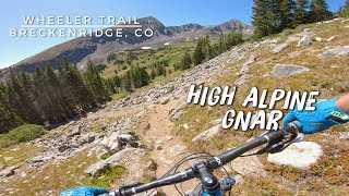
Once you reach the top of the ridge around 12,500 feet, high five your buddy and put your suspension into fun mode, because a ripping, steep descent into the Crystal Lakes drainage awaits you. The trail tread is very smooth, but extremely steep and if you haven't bled your brakes in a while, you'll learn about it real quick. As you reach tree line, the trail becomes more rocky and technical, although there are no stopper moves.
When you reach the
Crystal Lakes Road, continue straight on the singletrack through a fast rocky section with many natural jumps, becoming rooty and forested, before the trail spits you out onto an old road. Turn right and descend a short distance past a gate to another intersection. Look for the signed singletrack on the left towards
Wheeler Trail and
Spruce Creek Trail.
Climb and descend slightly until reaching a four-way intersection between the Wheeler and
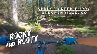
Spruce Creek Trail. Turn left, and descend a wide, fast, and very rooty section with occasional rocky sections to keep you honest. It's easy to carry a lot of speed here, but be careful, as this is one of the most popular hiking trails in Summit County. Expect to see a lot of traffic; yield and make mountain bikers look good.
Eventually, you'll pop out at the
Spruce Creek Trail. Take a left and prepare for one final, but short climb. You'll quickly come to an intersection in the road and you have two options. Continue pedaling straight on
Spruce Creek Road for a short distance until reaching
Burro Trail on the right, or go right and push your bike a short ways up
Crystal Lakes Road to reach
Burro Trail.
Burro Trail begins on an abandoned roadbed and descends moderately over embedded and sometimes loose rock. A few social trails branch off but for the most part the main tread is obvious. After a bit over a mile, the trail makes a hard right and leaves the old roadbed - look for a blue blaze and arrow, and a cairn, at this point.
Continue to follow the rocky and rooty singletrack, following the blue blazes on trees at intersections back to the Beaver Run parking lot. Like the
Spruce Creek Trail, the lower reaches of Burro are heavily used by families on foot so watch your speed and be courteous.

 Continue with onX Maps
 Sign in with Facebook


 Difficult

 4.2 (28)


6 Comments