This has been hidden from our maps to prevent overlap with existing trails, or because
our research has found there is no legal access.
Dogs Unknown

E-Bikes
Unknown
Features
Commonly Bikepacked

- This segment is the crux of the Plateau Passage route. Summer temps can soar to 100+ °F, water sources are widely spaced and require careful planning, and there are no resupply options until the end of this 233-mile section.
- Water is limited in the first 100 miles of the segment - reliable water sources in that part include only Sandy Ranch (mile 53) and a creek at mile 80. After Hite (mile 121), it could be as much as 80 miles until the next water during drier times.
Section Of
Description
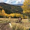
Segment 5 is the most remote of the Plateau Passage, immediately entering canyon country, climbing over two isolated mountain ranges, and reaching Monticello some 230+ miles later. The scenery is remarkable, and the sheer scale of the Colorado Plateau landscape is hard to comprehend. Careful planning is necessary as there are no resupply options between Boulder Town and Monticello, and water is scarce.
The first 60 miles of the segment follow the relatively famous Burr Trail Road and Notom Road from Boulder Town toward Capital Reef National Park. The riding is generally fairly easy and fast on these mostly graded dirt roads. Enjoy this while it lasts, as the route next climbs 5,000 feet toward the peaks of the Henry Mountains on 4x4 roads. This was the final mountain range in the Lower 48 to be mapped. From Bull Mountain Pass, just a few hundred feet lower than the adjacent summits, a 4x4 road drops back down 5,000 feet, followed by another 1,000-foot descent on a quiet highway to a crossing of the Colorado River near Hite. A former townsite, Hite now has little more than a gas station (where you can only buy gas!), a campground, and a ranger station for Glen Canyon National Recreation Area.
After Hite, the route climbs gradually among redrock buttes and narrow canyons on 4x4 roads toward Elk Ridge and the iconic pair of mesas known as Bears Ears. The views in all directions on this narrow ridgeline are dramatic, and the riding becomes relatively easy on the well-maintained, graded road. Elk Ridge leads to the base of the Abajo Mountains (also known as the Blue Mountains) and you'll come to the end of this segment at the town of Monticello by skirting around the southern side of the Abajos on graded dirt roads and a few miles of rugged ATV trail. Monticello is another small Colorado Plateau town but has a grocery store, lodging options, and numerous restaurants.
Contacts
Shared By:
Bikepacking Roots

 Continue with onX Maps
 Continue with Facebook


 Intermediate


0 Comments