Dogs Unknown

E-Bikes
Unknown

The iconic bar and grill, Cook's Corner, is protective of parking for its walk-in customers, so please respect their parking requirements for mountain bikers.
Overview
Once on dirt, this ride is one of the good ones. The climb is a rocky doubletrack with crazy good views of the OC and sunsets. The descent is a steep, twisting, cliff-exposed singletrack, more like a carved half-pipe, that snakes to the final paved downhill.
Yes, there's a good amount of riding on pavement, but at least some of it is 40mph downhill... er... huh-hum... actually officer, I was going the speed limit of 35mph, I swear.
Need to Know
All of the dirt on this ride is US Cleveland National Forest and, unlike state/county parks, does not close for rain or darkness (night riding!).
Description
From Cook's Corner, find a good gear and go right (northwest) up Santiago Canyon Rd. Pound out the 1.2 miles of mildly steep pavement and bear right onto Modjeska Grade Rd, a much steeper, paved, first gear grinder. About a 1/3rd of a mile of pain later turn right into a dirt staging area behind a rusted, iron trail gate. This is the start of
Santiago Truck Trail (STT).
The single/doubletrack climbs mildly through rocky terrain for 2.5 miles. Be careful not to ride off the trail when distracted by awesome views, especially at sunset. Descend for about 3/4ths of a mile to a rounded hilltop with a flagpole on its crown. This is the official start of
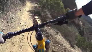
The Luge.
An insane rush, this skinny, carved half-pipe plunges steeply down the side of a cliff face, turning and dancing right on the edge. There are a number of 6"-12" drops along its length, sometimes within the turns, sometimes one on top of the other. The trail ends at Live Oak Canyon Rd where you turn right and enjoy the 35-40mph downhill rush back to your car.
Contacts
Shared By:
Dave Gregg
with improvements
by Nick S

 Continue with onX Maps
 Sign in with Facebook


 Difficult

 4.5 (81)


 All Clear


2 Comments