
 Continue with onX Maps
 Sign in with Facebook


 Intermediate/Difficult

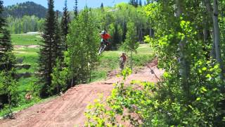
“A switchbacking trail that descends from the Mid-Mountain Trail all the way to the Canyons base. ”


4.1
Miles6.5
KMSingletrack
 Intermediate/Difficult
Local Club: Mountain Trails Foundation
Aug 7, 2025: Help Emma Take Her Next Step
Aug 7, 2025: Trails Are Forever
Aug 7, 2025: Perspective… Let’s Help Emma Paden
 MidWeekMTB Final Solitude Race - 1 Lapper
6.2 mi 10.0 km • 977' Up 297.86 m Up • 996' Down 303.43 m Down
 Alta, UT
 Mid Mountain Loop - IMBA EPIC
22.9 mi 36.8 km • 2,307' Up 703.06 m Up • 2,351' Down 716.44 m Down
 Park City, UT
Armstrong
Park City, UT
Armstrong
4.0 mi 6.5 km • 1,259' Up 383.75 m Up • 1' Down 0.23 m Down
Park City, UT
 Black Forest to Redbull Loop
12.9 mi 20.8 km • 2,468' Up 752.36 m Up • 2,474' Down 754.09 m Down
Park City, UT
Flying Dog Connector Loop
13.5 mi 21.6 km • 1,828' Up 557.29 m Up • 1,831' Down 558.01 m Down
Summit…, UT
Jenni's/Tommy's/Mojave/Mid Mountain/CMG
10.5 mi 17.0 km • 1,789' Up 545.34 m Up • 1,785' Down 544.14 m Down
Park City, UT


1 Comment