Dogs Unknown

E-Bikes
Not Allowed
Overview
Similar to the road version, the Dirty Copper Triangle (aka Copper Three Pass) traverses three high alpine passes: Searl Pass and Kokomo Pass along the Colorado Trail, and Ptarmigan Pass along Resolution Road above Camp Hale. The ride incorporates the Colorado Trail: Copper Mountain to Camp Hale,
Resolution Mountain Road #702,
Wilder Gulch Trail,
Wilder Gulch Connector, and the
Vail Pass to Copper Bike Path in an epic loop ride.
The Latitude 40, Vail and Eagle, Recreational Topo Map is a great resource for this ride as it covers the entire route. The ride spans two Ranger Districts: Holy Cross and Dillon within the White River National Forest. Free maps are available at WRNF offices.
Need to Know
Each of the three passes tops out around 12,000 feet. That means
very thin air. Even for acclimatized riders, this can result in a significant reduction in handling skills. Riders not accustomed to high altitude should be attentive to their bodies and be ready to abandon at the onset of altitude sickness.
The Colorado Trail: Copper Mountain to Camp Hale is an awesome, unique ride; however the last mile to Camp Hale is loose, and quite steep.
Resolution Mountain Rd. is a popular 4WD road, with lots of traffic. Couple this with a brutal 5.5 mile climb averaging over 10% grade for the top 2.5 miles, and the final 1.5 miles at nearly 14% can make this final climb frustrating.
The final 3.5 miles, and 600' of descent utilizes paved bike path, which can feel discouraging after the effort put in to get there. Alternatively, extremely adventurous riders may choose to descend the
Wearyman Road #747.1 (read the details first!) and then climb up the vehicle road at the bottom.
Description
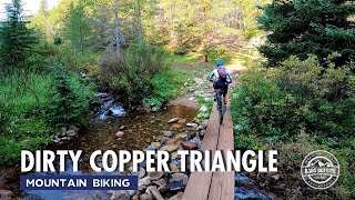
Drive to the west end of Copper Mountain passing through a roundabout and park at the small parking lot on the right side of the road near the eastern end of the Vail Pass bike path. Ride back through, and south out of the roundabout towards the ski area on Copper Circle. Climb the access road south of the American Eagle chairlift to the first switchback, and the Colorado Trail intersection. The CT follows the access road west through this intersection. At the next switchback and road junction, exit the road onto a singletrack to the west.
The CT throughout Colorado is well marked. Copper Mountain is no different. The CT winds for about 1 1/4mi through Copper Mountain before exiting the ski area, passing through a forested area. The trail descends briefly, crossing Guller Creek, then climbs roughly parallel to the creek for 2 3/4mi. From here the CT switches back to the north and begins to climb above Janet's Cabin. After 1/4mi and another switchback the CT clears timberline. From this point to a mile below Kokomo Pass, the ride stays above timberline; which means exposure.
Continue south for another 1 1/4 over a mostly rideable section of trail to Searl Pass. At the pass enjoy the views, a snack, and a well-deserved break. This is also a good point to turn around if weather conditions, or physical fitness are questionable; bearing in mind that the ride back to Copper Mountain is 7 miles and incorporates a short climb back into the ski area boundary.
The CT between Searl and Kokomo Passes is a very unique, timberline traverse, punctuated with short, stinger climbs. The ride high point is 1/2 mile east of Kokomo Pass. Again, offering stunning views to the south and Climax Mine; and a second opportunity to assess conditions and fitness.
This is the ride commitment point.
Descend 1/2 mile to Kokomo Pass, and continue a blistering 5 mile descent to Camp Hale. There are absolutely stunning views to the west of the Holy Cross Ridgeline including Mountain of the Holy Cross in the first mile below Kokomo Pass.
3.5 miles below Kokomo Pass, cross Cataract Creek. Below this crossing the trail becomes pretty steep and loose, so get that butt behind the saddle. A mile below the creek crossing bottom out at the southeastern corner of Camp Hale on road 714, East Fork Eagle Road. Go right on the road, then turn right back onto the CT singletrack. The CT parallels 714 for 2/3 mile before dropping back down to the road. This is where the ride deviates from the CT and is also the ride midpoint.
Follow 714 along the eastern edge of Camp Hale, passing 755, Ranch Creek Road on the right after 1/2 mile, as well as numerous roads to the left comprising the grid of roads that was Camp Hale. After 2 1/4 miles intersect
Resolution Mountain Road #702 at a well-defined intersection. Turn right and begin the final climb of the day. Be prepared to share the road with numerous off-road vehicles as you climb.
There are three distinct road intersections along this climb: the first near the bottom with 708, McAllister Gulch Road on the left; the second 715, Pearl Creek Road on the right at 1 1/2 miles; and the last 751, Ptarmigan Road above timberline on the left, 1/2 mile from the summit of Ptarmigan Pass.
Top out at Ptarmigan Pass, and exalt in the fact that you've made it to the top and the remainder of the ride is downhill. Finding
Wilder Gulch Trail from Ptarmigan Pass is the only real wayfinding along this ride.
Wilder Gulch Trail is 3/4 miles from the summit of the pass, on the right side of the road in a sweeping left turn. The trail begins in a meadow, over timbers that have been piled to prevent motorcycles entering the trail.
Wilder Gulch Trail does not receive heavy traffic, giving it a primitive feel. Descend 2 1/4 miles in the meadow along Wilder Gulch to an intersection with
Wilder Gulch Connector. Turn right and descend to
Vail Pass to Copper Bike Path. Turn right and coast down to the parking lot. Drink beer!
History & Background
From Wikipedia:
en.wikipedia.org/wiki/Camp_…
Camp Hale, between Red Cliff and Leadville in the Eagle River valley in Colorado, was a U.S. Army training facility constructed in 1942 for what became the 10th Mountain Division. It was named for General Irving Hale.
Soldiers were trained in mountain climbing, Alpine and Nordic skiing, cold-weather survival as well as various weapons and ordnance. When it was in full operation, approximately 15,000 soldiers were housed there.
The creation of an elite ski corps was a national effort, with assistance from the National Association of Ski Patrol, local ski clubs, and Hollywood. Enough men were recruited to create three army regiments, which were deployed after training. Camp Hale was decommissioned in November 1945.
Contacts
Shared By:
D L

 Continue with onX Maps
 Sign in with Facebook


 Difficult


 Rendezvous Lift Out-and-Back
 River Trail

 Hard Luck Trail
 Burro-Spruce Creek-Burro


12 Comments