 Race - Mar 28, 2020
Dogs Unknown

E-Bikes
Unknown
Overview
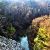
Now in its second decade, this unique event provides a sixty-plus-mile loop and two days of mountain bike touring and racing on two of our best trails. The Ouachita Trail is known for its challenging climbs, vast technical sections, and scenic views of the Ouachita River. The Womble Trail - IMBA Epic is known for its fast trail and scenic views of the Ouachita Mountains and valleys.
Description
This is a fun ride and in keeping with that theme, we are allowing personal/individual support at key points along the route. Safety is our major concern. We suggest support at Brushy Creek Rec. Area along Hwy 270. That's the first Aid Station. Also we suggest support at Sims Fire Station on Hwy 88. Hee Gap is also a good support area. These are public places and racers and their support are not the only persons in the area. Please be careful when driving to these places. Please respect others that might not be involved with the race. Safety for the riders and support persons is our major concern.
Alternative start #1
Head East on Highway 88 for 100 yards
Turn left (north) on to road 536 - next to the store
Continue on 536 (Brushy Road) passing Brushy Church and crossing Brushy Creek
Turn left on FR (JO) 6 and continue (south) to FR 48
Turn right (west) on 48
Follow FR 48 to the Ouachita Trail
Turn right onto the Ouachita Trail
Alternative start #2
Head west on Highway 88
Turn right onto Forest Road (FR) 48 just past the Oden Ranger Station
Follow FR 48 staying left at the junction with J-06 (FS 6)
Continue on FR 48 to the Ouachita Trail (OT) junction and turn right
Then follow OT to FR 6 and turn left
Follow FR 6 to the OT about 60 yards past Brushy Creek Bridge and turn right
Follow OT to Hwy 270 and turn right
Follow Hwy 270 for 200 yards and turn left onto the OT at the end of the guard rails
Follow OT and veer right across FR 33 to continue on OT
On Saturday, the Tour riders will go around Blowout Mt. by taking FS 33 north, FS 17 east and connecting to FS 274 (Fiddler Creek Rd.) where they will rejoin the Ouachita Trail
Follow the OT to FR 274 and turn left
Follow FR 274 and turn right onto the OT
Follow the OT to FR 149 and turn right
Follow FR 149 to Rainey Creek Rd
Follow Rainey Creek Rd (do not take the right turn FR 562) to Sims Loop Rd and turn right (Road 2262)
Follow the paved road through Sims and the Sims Fire Station
Turn left on Highway 88, go south to the intersection of 88 and 298
Stay right on Highway 298 crossing the Ouachita River
Continue on 298 to the 298 parking lot area (this will be a very congested area on the days of the events so be alert and follow the directions of the race officials)
Riders will be directed across Highway 298 onto Road 568 toward Fulton Branch Campground
Continue on 568 to FS 2291 stay right
Turn right on to the Womble Trail
Follow the Womble Trail west back to the Highway 298 parking lot (aid station)
Race officials will direct you across Highway 298 and continue west on the Womble trail
Follow Womble Trail crossing Highway 270, FR 922, FR92 over Gaston Mtn to FR 68
Turn right on FR 68 then left on FR 74 toward North Fork Lake
At North Fork Lake, take the Womble Trail north back to FR 68
Turn right (east) on FR 68 continue to the junction with FR 92
Turn left (north) on FR 92
Continue north crossing the Womble Trail and continue on FR 92 and County Road 379 to Highway 88 and Oden School
Shared By:
Jesus Villarreal

 Continue with onX Maps
 Continue with Facebook


 Difficult

 Womble Trail - IMBA EPIC

 Mount Ida, AR
 Big Brushy


 All Clear


0 Comments