
 Continue with onX Maps
 Continue with Facebook


 Intermediate/Difficult

“West Pine Creek has challenging climbs and grin-inducing descents with awesome views too. ”


6.1
Miles9.9
KMSingletrack
 Intermediate/Difficult
Local Club: Livingston Bicycle Club
Land Manager: USFS - Gallatin National Forest Office
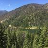
 Emerald Lake
9.2 mi 14.9 km • 1,826' Up 556.5 m Up • 1,826' Down 556.44 m Down

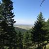
 Bozeman, MT
 Mystic Lake
15.5 mi 24.9 km • 3,207' Up 977.46 m Up • 3,206' Down 977.31 m Down
 Mystic Lake
20.4 mi 32.8 km • 1,473' Up 448.92 m Up • 1,472' Down 448.8 m Down
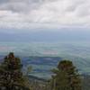
Bozeman, MT
Leverich Canyon
4.9 mi 7.9 km • 1,235' Up 376.55 m Up • 1,143' Down 348.48 m Down
Bozeman, MT
Bangtail Divide - IMBA EPIC
25.0 mi 40.2 km • 3,611' Up 1100.51 m Up • 3,309' Down 1008.66 m Down
Bozeman, MT
Sypes Canyon to Middle Cottonwood
7.6 mi 12.3 km • 2,331' Up 710.55 m Up • 2,076' Down 632.85 m Down


0 Comments