Dogs Leashed

E-Bikes
Unknown
Description
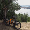
After leaving D and D trailhead, this is the right fork. This trail takes you up Johnson Peak and has some of the best views on the ride. The climb is more sustained than most others and has a few more technical sections. Eventually, you'll come to a spur that will take you to the very top. It's definitely a hike-a-bike for most riders. It also seems to be more congested than the rest of the trail from hikers making their way up.
If you go up, make sure you go right when you come back down to continue on. If not, just stay straight at the intersection. You'll cross a fire road, and from here the fun begins. All of the hard climbing is over.
After a nice, high-speed section, you'll come to a lookout and the lake will be right in front of you. The trail curves to the left and stays level for a while before a final long downhill run.
Contacts
Shared By:
Ray Nelson

 Continue with onX Maps
 Continue with Facebook


 Intermediate/Difficult


0 Comments