
 Continue with onX Maps
 Continue with Facebook


 Intermediate

“The second half of the road climb to the Dalles Ridge Trailhead. ”


2.6
Miles4.2
KMDoubletrack
 Intermediate
Local Club: Evergreen Mountain Bike Alliance
Land Manager: USFS - Mt. Baker-Snoqualmie National Forest Office
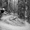
 Ranger Creek Loop
22.8 mi 36.7 km • 3,833' Up 1168.16 m Up • 3,834' Down 1168.66 m Down

 Buckley, WA
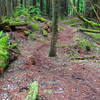
 Skookum Flats Ride
10.8 mi 17.3 km • 621' Up 189.13 m Up • 620' Down 189.01 m Down
Little Bald Mountain Loop
23.4 mi 37.6 km • 3,589' Up 1093.96 m Up • 3,589' Down 1093.9 m Down


0 Comments