
 Continue with onX Maps
 Continue with Facebook


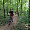
 Intermediate/Difficult

“A fun ride that seems downhill both ways. ”


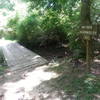
1.6
Miles2.6
KMSingletrack
 Intermediate/Difficult
Local Club: SORBA - Huntsville
Land Manager: Land Trust of North AL
 Monte Sano Mountain - Flat Rock Loop
15.1 mi 24.2 km • 998' Up 304.29 m Up • 997' Down 303.84 m Down


 Monte Sano Plateau Loop
7.0 mi 11.3 km • 249' Up 75.9 m Up • 249' Down 75.99 m Down
Huntsville, AL
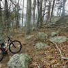
 Blevins Gap Scenic Ride
4.0 mi 6.5 km • 450' Up 137.26 m Up • 449' Down 136.79 m Down
 Duck Weed Basin
4.5 mi 7.3 km • 20' Up 6.14 m Up • 20' Down 6.12 m Down
Hays Nature Preserve
4.0 mi 6.5 km • 33' Up 9.97 m Up • 33' Down 9.99 m Down
 Lake Guntersville State Park - Figure 8
9.1 mi 14.7 km • 747' Up 227.75 m Up • 725' Down 220.94 m Down


0 Comments