
 Continue with onX Maps
 Continue with Facebook


 Difficult

“Some of the best biking in the San Gabriel Mountains. ”


13.8
Miles22.2
KMSingletrack
 Difficult
Local Club: Mount Wilson Bicycling Association
Land Manager: USFS - Angeles National Forest Office
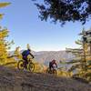
 Mt. Wilson Enduro Loop
32.5 mi 52.3 km • 6,479' Up 1974.7 m Up • 6,487' Down 1977.37 m Down

 Monrovia, CA
Winter Creek Loop
Monrovia, CA
Winter Creek Loop
4.9 mi 7.9 km • 1,236' Up 376.75 m Up • 1,245' Down 379.49 m Down
Sierra…, CA
 West Fork National Scenic Bikeway
14.5 mi 23.3 km • 948' Up 289.07 m Up • 948' Down 289.01 m Down
Glendora, CA
Strawberry Peak Loop
15.6 mi 25.0 km • 2,593' Up 790.29 m Up • 2,603' Down 793.49 m Down
Altadena, CA
 Blue Ridge Loop
6.3 mi 10.2 km • 1,089' Up 332.05 m Up • 1,098' Down 334.78 m Down
Wrightwood, CA
Lower Monroe Truck Trail
16.1 mi 25.9 km • 2,319' Up 706.97 m Up • 2,319' Down 706.93 m Down
Glendora, CA


5 Comments