This has been hidden from our maps to prevent overlap with existing trails, or because
our research has found there is no legal access.
Dogs Unknown

E-Bikes
Unknown
Description
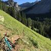
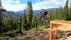
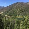
Upper South Fork trail ends on the Middle fork access road, where you can cross and take a narrow trail down Middle Fork, aka poop shoot which alternates between singletrack and open nordic trail, with views of the creek and gentle grade all the way.
Watch for a left turn, across the creek about half way down, and near the end take a steep short climb and right turn to end on Andesite Road, just above Town Center.
This can also be used as an out and back climb, or continue on to connect with other Big Sky Resort trails.
Contacts
Shared By:
Phil Hess

 Continue with onX Maps
 Continue with Facebook


 Difficult


0 Comments