
 Continue with onX Maps
 Continue with Facebook


 Intermediate


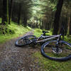
“Streamhill loop takes you to the highest point in Ballyhoura and will keep you busy a good bit of the day ”


25.6
Miles41.2
KMSingletrack


0 Comments