
 Continue with onX Maps
 Continue with Facebook


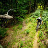
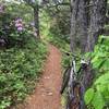
 Very Difficult

“Steep, rocky, off-camber gnar singletrack descending the tallest mountain in the GWNF. ”


2.3
Miles3.7
KMSingletrack
 Very Difficult
Local Club: Shenandoah Valley Bicycle Coalition
Feb 28, 2024: 30+ Years of Partnership at the Massanutten Western Slope
Feb 26, 2024: Action Alert – Safer Bicycling
Feb 17, 2024: The Future of the Western Slope
Land Manager: USFS - George Washington & Jefferson National Forests
 Southern Traverse - IMBA EPIC
36.4 mi 58.5 km • 3,946' Up 1202.66 m Up • 3,970' Down 1209.96 m Down

 Verona, VA
Braley's Pond & Confederate Breastworks Loop
Verona, VA
Braley's Pond & Confederate Breastworks Loop
18.0 mi 29.0 km • 2,753' Up 839.1 m Up • 2,758' Down 840.51 m Down
 Lookout Mountain from Stokesville
8.8 mi 14.2 km • 1,398' Up 426.26 m Up • 1,441' Down 439.36 m Down
Bridgew…, VA
Reddish Knob to Wild Oak: Chestnut & Grindstone Ridge Shuttle
13.3 mi 21.4 km • 975' Up 297.29 m Up • 3,733' Down 1137.82 m Down
Sherando Variety Pack
14.0 mi 22.5 km • 1,949' Up 593.95 m Up • 1,962' Down 597.9 m Down
Stuarts…, VA
Brushy Hollow, Stony Run & Fore Mountain North
19.1 mi 30.7 km • 2,771' Up 844.59 m Up • 2,818' Down 858.83 m Down
Clifton…, VA


0 Comments