
 Continue with onX Maps
 Continue with Facebook


 Intermediate


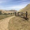
“A steady fire road descent from Curry Point into Curry Canyon. ”


2.6
Miles4.1
KMDoubletrack


0 Comments