
 Continue with onX Maps
 Continue with Facebook


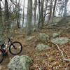
 Intermediate

“A gateway trail showcasing what Lake Guntersville State Park has to offer. ”


3.3
Miles5.4
KMSingletrack
 Intermediate
Land Manager: Alabama State Parks
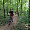
 Lake Guntersville State Park - Figure 8
9.1 mi 14.7 km • 747' Up 227.75 m Up • 725' Down 220.94 m Down


 Noccalula Fall Evaluation - Alabama MTB 2020
4.7 mi 7.6 km • 588' Up 179.2 m Up • 566' Down 172.64 m Down
Gadsden, AL
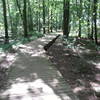
 Hays Nature Preserve
4.0 mi 6.5 km • 33' Up 9.97 m Up • 33' Down 9.99 m Down
Monte Sano Plateau Loop
7.0 mi 11.3 km • 249' Up 75.9 m Up • 249' Down 75.99 m Down
Huntsville, AL
Monte Sano State Park - Family Bike Trail
4.5 mi 7.2 km • 152' Up 46.39 m Up • 152' Down 46.42 m Down
Huntsville, AL
Tri for Ole Glory Route
4.2 mi 6.7 km • 161' Up 48.94 m Up • 162' Down 49.45 m Down


0 Comments