Dogs Unknown

E-Bikes
Not Allowed
Overview
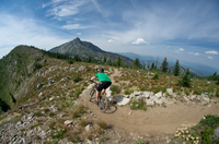
A fun trail that that starts out as ATV-width doubletrack but soon becomes more interesting, primitive singletrack. Not heavily used, the trail has a backcountry feel. The section up to Pinkham Butte on South
Pinkham Trail provides excellent views of the Blues and the surrounding canyons.
Best ridden in the early Spring or mid to late Fall to avoid rattlesnakes and an overabundance of ticks.
Need to Know
The Discover Pass is required for parking at the trailhead. No pay station is currently provided, so plan ahead. Hunting is popular in this area in the fall, so wearing bright colors is advised.
Description
This ride is pretty easy to navigate as an out and back and there are no intersections riding it this way.
From the parking lot cross Lick Creek, which could be flowing pretty high during the Spring due to snow melt. It will most likely be dry in the Fall. The first 6 miles are ATV-width doubletrack with a gradual climb. At the beginning of the singletrack, the trail will begin to climb steeper along the hillside with nice views of the canyon. The grade continues along at a more gradual grade shortly after that.
At about 10.5 miles in you'll come to South
Pinkham Trail. From here, the trail ascends 1,000' in 1.1 miles. It is not overly technical, but there is some exposure along the hillside. Once up top, there are great views to the south of the Blue Mountains. Enjoy the descent back down South
Pinkham Trail to Asotin Creek. The ride down North Fork Asotin Creek - Trail #3125 is fast and flowy in sections. Just be aware horseback riders and hikers use this trail as well.
Contacts
Shared By:
Kyle F
with improvements
by ZANE Krempel

 Continue with onX Maps
 Sign in with Facebook


 Intermediate/Difficult


0 Comments