
 Continue with onX Maps
 Continue with Facebook


 Difficult

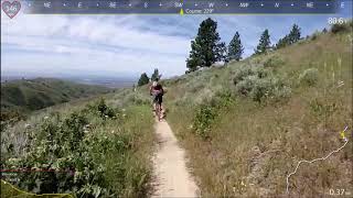
“A tight descent down into Sinker Creek. ”


1.9
Miles3.0
KMSingletrack
 Difficult
Local Club: Southwest Idaho Mountain Bike Association
Land Manager: Ridge to Rivers
 Stack Rock Loop
11.4 mi 18.3 km • 1,144' Up 348.62 m Up • 1,146' Down 349.2 m Down

 Boise, ID
 Bogus Mountain Tour
10.0 mi 16.0 km • 1,349' Up 411.31 m Up • 1,352' Down 412.06 m Down
Red Cliff to Bobs to Lower Hulls
9.9 mi 15.9 km • 1,504' Up 458.56 m Up • 1,508' Down 459.49 m Down
Boise, ID
Watchman Chicken Leg Burner
13.9 mi 22.3 km • 2,288' Up 697.31 m Up • 2,280' Down 694.95 m Down
Sanford and Son
18.4 mi 29.6 km • 2,521' Up 768.45 m Up • 2,518' Down 767.39 m Down
Showcase
15.3 mi 24.6 km • 2,095' Up 638.5 m Up • 2,091' Down 637.42 m Down


0 Comments