Dogs Off-leash

E-Bikes
Not Allowed
Features
Drops/Jumps

Some foot traffic near the campground areas, USE CAUTION. It is a deceptively fast trail and foot traffic tends to have kids, dogs, strollers, etc. so keep a finger on the brakes, and tires on the ground.
Description
The trail is best accessed from the Nordic Ski Patrol facility at the top of Mt. Pinos where there is ample parking for the shuttle vehicle(s). There are cross country skiing trails and signs up top that can be confusing. Follow the bike tracks.
Pick up the trail heading straight out the back of the parking area where you veer right to the hike-in campground. Before even entering the campground, veer right again.
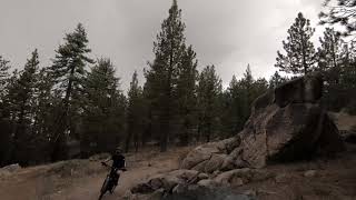
The trail will start to descend very rapidly. The 1st segment up to the 1st road crossing is called Hazard trail, but there aren't any signs indicating that. There are several XC nordic ski trails leading off here and there that loop the top of the mountain, don't take those. Stick to the path well traveled, all the off-shoots are faint and narrow. After the road crossing there is a sweet double drop-off, but be careful launching as it is a deceptively soft landing. Right after that is a log jump I do not recommend as it is always in some state of disrepair and could easily be un-rideable and a HAZARD!
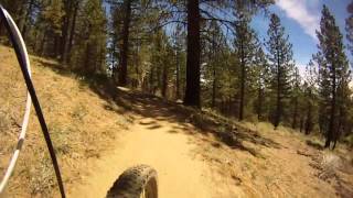
You pop out into another campground where you'll cut across and pick up the trail on the opposite side of camp. Stay level here, don't climb up or go down in the camp you'll get lost. Look for some sign posts between 2 campsites, that's where Ridgeline (again, no signs) trail picks up. This is a super fun section with nice kickers and big berms. Watch out for people through here.
You'll cross the road again and this where McGill trail officially picks up. After a short climb you get to very confusing 5-way intersection.
Contacts
Shared By:
Paul Rogers
with improvements
by James M

 Continue with onX Maps
 Continue with Facebook


 Intermediate/Difficult

 4.6 (25)


2 Comments