Dogs Off-leash

E-Bikes
Unknown
Overview
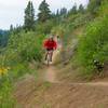
The highlight to this trail is a 9 mile stretch of long, flowy singletrack that takes you along the ridgeline of Buck Mountain. Forest roads on both the South West (
Cub Creek Road) and North East (NF-100) provide access points to the trail. Doing a loop is about 60% singletrack; making it a figure 8 is about 50% singletrack.
A mixture of evergreens and dry brush gives way to spectacular views throughout the trail.
Need to Know
Parking is available at large pullout along Cub Creek road near the trail access. Do not block the private driveway/trail at the south (downhill) end of pullout.
Description
Start up
Cub Creek Road. Keep right to stay on FS 100. Don't get pulled left on FS 52 to either Rendezvous or Mazama. After ~1,100 feet of climbing on road, you'll reach the "Deer Country" sign and the turnoff to the
Buck Mountain Trail.
The road branches, climb to the right up doubletrack, which is marked with a yellow bike route marker.
Buck Mountain Trail is around 9 miles of singletrack which eventually intersects with a doubletrack road (
NF-025 Forest Road), which you'll want to turn left (down hill) on. This doubletrack takes you back to
Cub Creek Road. You can add-on to this by taking a left on the
Buck Lake Trail at the junction a few minutes before you intersect with NF-025, which will take you all the way to Buck Lake.
Follow the doubletrack around the north side of the lake, past the campground, and follow the doubletrack (NF-100) around the north side of Buck Mountain and eventually follow it to the left at NF-155. This will eventually reconnect you to the north point of
Buck Mountain Trail. This adds approximately 10 miles to this 13 mile route.
Contacts
Shared By:
Tony Locati

 Continue with onX Maps
 Continue with Facebook


 Intermediate

 4.2 (26)


6 Comments