Dogs Unknown

E-Bikes
Unknown
Description
Black Ridge is the south extension of the Red Rocks trail. It is best done as a steep (and occasionally loose) descent from north to south.
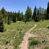
The first section contains rolling doubletrack with lots of slickrock. Stop along this section at the top to get excellent views of the Black Canyon and Gunnison Gorge.
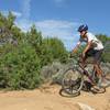
After the doubletrack you drop into a steep and loose section coming down the ridge to the south. This section is really fun, but watch out for a couple of steep drop-offs.
Once the trail levels out you'll have some fun technical slickrock sections that drop you back down to Chuckar Road. If you cross Chuckar Road you can continue on for a short distance to a well marked parking lot. To get back west you can take Chuckar Road or Moonlight Mesa/
Mystery Ditch which will get you back near the
Sunset Rocks trailhead.
Contacts
Shared By:
Tim Judkins

 Continue with onX Maps
 Continue with Facebook


 Very Difficult


0 Comments