
 Continue with onX Maps
 Continue with Facebook


 Intermediate/Difficult

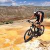
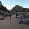
“A nice climb along Thompson Ridge to the upper San Antonio Canyon. ”


6.0
Miles9.7
KMSingletrack
 Intermediate/Difficult
Local Club: Los Alamos Singletrack Association
Land Manager: USFS - Santa Fe National Forest Office
 San Antonio Creek Route
18.9 mi 30.4 km • 1,127' Up 343.51 m Up • 1,127' Down 343.61 m Down

 East Fork Eastern Loop
8.9 mi 14.4 km • 820' Up 250.08 m Up • 820' Down 249.94 m Down
 Valles Caldera: NW Side
40.1 mi 64.6 km • 2,352' Up 716.97 m Up • 2,352' Down 716.89 m Down
 Quemazon - Guaje Ridge - Cabra - Perimeter Loop
18.9 mi 30.4 km • 3,101' Up 945.28 m Up • 3,102' Down 945.37 m Down
White Ridge Trail System - Main Loop
8.4 mi 13.5 km • 831' Up 253.34 m Up • 825' Down 251.4 m Down
 Jemez P…, NM
Dead Dog Well Loop
Jemez P…, NM
Dead Dog Well Loop
20.9 mi 33.6 km • 1,733' Up 528.21 m Up • 1,733' Down 528.24 m Down


1 Comment