
 Continue with onX Maps
 Continue with Facebook


 Intermediate

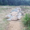
“A fun climb through the woods with a moderate technical descent ”


1.0
Miles1.7
KMSingletrack
 Intermediate
 French Creek Loop
11.3 mi 18.2 km • 1,074' Up 327.29 m Up • 1,078' Down 328.67 m Down

 White Clay Creek State Park & Middle Run Valley Natural Area
12.4 mi 20.0 km • 715' Up 217.87 m Up • 714' Down 217.54 m Down
 Pike Creek, DE
 Valley Forge Historical Loop
5.2 mi 8.4 km • 273' Up 83.3 m Up • 276' Down 83.99 m Down
North Lot Loop
12.9 mi 20.8 km • 1,059' Up 322.69 m Up • 1,059' Down 322.77 m Down
Fair Hill, MD
 Canal Street Pub to Blue Marsh Lake via Schuylkill River Trail (SRT) & Union Canal Trail
10.4 mi 16.7 km • 282' Up 85.88 m Up • 228' Down 69.42 m Down
 Green Lane Park Loop
15.4 mi 24.8 km • 1,646' Up 501.75 m Up • 1,643' Down 500.88 m Down


0 Comments