
 Continue with onX Maps
 Continue with Facebook


 Difficult

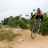
“A super fun trail with small-ish rock drops and good flow most of the way down. ”


1.5
Miles2.4
KMSingletrack
 Difficult
Local Club: San Diego Mountain Biking Association (SDMBA)
Land Manager: City of San Diego - Parks & Recreation
 Cowles Mtn
5.4 mi 8.6 km • 1,211' Up 369.03 m Up • 1,224' Down 373.02 m Down

 SDMBA Summit Park and Bonita Golf Course loop
4.4 mi 7.1 km • 324' Up 98.79 m Up • 326' Down 99.38 m Down
 La Presa, CA
2019 Archipelago Ride Half Arch
La Presa, CA
2019 Archipelago Ride Half Arch
23.6 mi 38.1 km • 2,246' Up 684.64 m Up • 2,734' Down 833.34 m Down
Poway, CA
Penasquitos Tour
10.8 mi 17.5 km • 825' Up 251.36 m Up • 816' Down 248.61 m Down
San Dieguito River Park - Bernardo Bay/ Piedras Pintadas Trail
8.2 mi 13.2 km • 570' Up 173.78 m Up • 567' Down 172.96 m Down
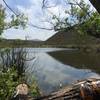
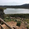
Lake Hodges North Side
10.2 mi 16.4 km • 294' Up 89.75 m Up • 294' Down 89.75 m Down
Escondido, CA


2 Comments