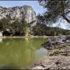
“Physical and technical route that winds along slabs at the top of dramatic limestone cliffs for part of the way. ”
13.9
Miles22.3
KMSingletrack

 Unknown
 Tour of Mont Ventoux
93.3 mi 150.2 km • 12,498' Up 3809.32 m Up • 12,518' Down 3815.34 m Down


 Sault, FR
 Grande Traversée Luberon
152.2 mi 244.9 km • 19,432' Up 5922.91 m Up • 19,437' Down 5924.33 m Down


 Maubec, FR
 Bédoin - Le Rat Loop
24.5 mi 39.4 km • 3,538' Up 1078.28 m Up • 3,523' Down 1073.7 m Down


 Bédoin, FR
 Les Opies-Aureille Loop
12.0 mi 19.3 km • 1,307' Up 398.27 m Up • 1,316' Down 400.97 m Down


 Aureille, FR
 Plateau de la Caume Loop
15.0 mi 24.1 km • 2,226' Up 678.34 m Up • 2,225' Down 678.3 m Down


 Saint-R…, FR
 Cairanne Loop
19.2 mi 30.9 km • 2,623' Up 799.5 m Up • 2,616' Down 797.24 m Down


 Sainte-…, FR


0 Comments