
 Continue with onX Maps
 Continue with Facebook


 Difficult

“A beautiful mid-summer trail with lots of wildflowers. ”


0.8
Miles1.3
KMSingletrack
 Difficult
Local Club: Applegate Trails Association
Land Manager: BLM/USFS-Grants Pass Office
 Horse Springs Out-and-Back
5.8 mi 9.4 km • 1,141' Up 347.9 m Up • 1,142' Down 348.02 m Down
 Little Greyback - Mule Mountain Loop
17.9 mi 28.7 km • 3,581' Up 1091.4 m Up • 3,568' Down 1087.43 m Down

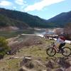
 Applegate Lake
17.2 mi 27.6 km • 1,192' Up 363.27 m Up • 1,181' Down 360.06 m Down
 Cook and Green Trail
14.2 mi 22.8 km • 2,392' Up 729.21 m Up • 2,390' Down 728.39 m Down
Bear Gulch - Tunnel Ridge Loop
4.7 mi 7.5 km • 729' Up 222.16 m Up • 731' Down 222.89 m Down
Britt Woods
5.1 mi 8.2 km • 832' Up 253.45 m Up • 833' Down 254.01 m Down


0 Comments