
 Continue with onX Maps
 Continue with Facebook


 Intermediate

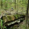
“A fast downhill connector between two main trails that passes historic ruins. ”


0.4
Miles0.6
KMSingletrack
 Intermediate
Local Club: River Valley Mountain Bike Association
Land Manager: Mountwood Park
 Mountwood Park Grand Tour Loop
22.4 mi 36.0 km • 2,396' Up 730.39 m Up • 2,397' Down 730.48 m Down

 Deerwalk, WV
 Bean Ridge/Bear Run Old School Classic
14.4 mi 23.2 km • 1,832' Up 558.51 m Up • 1,832' Down 558.45 m Down
Newport, OH
 Wayne Mini-Epic
25.4 mi 40.9 km • 2,647' Up 806.75 m Up • 2,647' Down 806.88 m Down
Newport, OH
 Broughton's Bonus Loop
5.2 mi 8.3 km • 569' Up 173.52 m Up • 573' Down 174.68 m Down
Devola, OH
Ohio View/Jackson Run Lollipop
15.5 mi 25.0 km • 1,963' Up 598.38 m Up • 1,963' Down 598.24 m Down
New Mat…, OH
Wayne National Forest Epic
34.8 mi 55.9 km • 3,227' Up 983.67 m Up • 3,256' Down 992.28 m Down
New Mat…, OH


 All Clear


0 Comments