
 Continue with onX Maps
 Continue with Facebook


 Intermediate

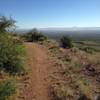
“A convenient connector between the Tom Mays and Canutillo Hills areas. ”


1.8
Miles2.8
KMSingletrack
 Intermediate
Local Club: Borderland Mountain Bike Association (BMBA)
Dec 7, 2023: The first-ever weather station on the Franklin Mountains by the BMBA.
Oct 30, 2023: Borderland Mountain Bike Association Takes on the Chupacabras Mountain Bike Race in Mexico
Oct 3, 2023: Restoring Natural Beauty: BMBA and Volunteers Erase Graffiti from Lost Dog Trail
Land Manager: City of El Paso, TX - Parks and Recreation
 Sotol Loop
12.3 mi 19.8 km • 1,053' Up 320.98 m Up • 1,055' Down 321.51 m Down
 Westway, TX
 Old Blue Mad Lazy Cow Loop
8.9 mi 14.4 km • 645' Up 196.5 m Up • 642' Down 195.81 m Down
 Westway, TX
Cow Tech
Westway, TX
Cow Tech
10.2 mi 16.4 km • 682' Up 207.94 m Up • 683' Down 208.14 m Down
Westway, TX
El Paso Puzzler 50-Mile Endurance MTB Race
51.0 mi 82.1 km • 5,676' Up 1730.17 m Up • 5,666' Down 1726.85 m Down
Westway, TX
North Anthony's Nose Loop
10.9 mi 17.5 km • 564' Up 172.03 m Up • 561' Down 171.01 m Down
Arroyo Park Loop
1.8 mi 2.9 km • 129' Up 39.31 m Up • 129' Down 39.33 m Down


0 Comments