
 Continue with onX Maps
 Continue with Facebook


 Difficult

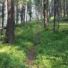
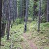
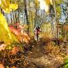
“A nice high country trail on the Idaho - Montana border! ”


19.4
Miles31.2
KMSingletrack
 Difficult
Local Club: Pend Oreille Pedalers (POP)
Land Manager: USFS - Idaho Panhandle National Forests Office
 Baldy Mountain Ride (Shuttle)
6.1 mi 9.9 km • 688' Up 209.68 m Up • 2,048' Down 624.1 m Down

 Redtop Mountain Loop
8.1 mi 13.0 km • 1,819' Up 554.34 m Up • 1,814' Down 552.86 m Down
 Brush Lake Trail
5.6 mi 9.0 km • 522' Up 159.01 m Up • 523' Down 159.3 m Down
Bonners…, ID
Timber Mountain Loop
9.8 mi 15.8 km • 2,164' Up 659.7 m Up • 2,155' Down 656.74 m Down
 Orville Heath/Kelly Pass Loop
13.3 mi 21.3 km • 2,031' Up 619.16 m Up • 2,040' Down 621.72 m Down
Timber Mountain - Buck Mountain Trail Loop
12.8 mi 20.7 km • 2,403' Up 732.34 m Up • 2,405' Down 732.91 m Down


0 Comments