Dogs Leashed

E-Bikes
Unknown
Overview
With the trailhead just a quarter mile off Hwy 101, there's no reason not to enjoy this ride if you're traveling along the Oregon coast. These hills around Cape Perpetua often rise above the coastal fog. Old-growth forest, ferns, a variety of trail surfaces, and a fun downhill make this route a memorable one.
Need to Know
Most trails in the area of Cape Perpetua are closed to mountain bikes, but this ride is the exception. Be aware that this trail is also popular with hikers.
The beach across the highway at Neptune State Park is a good place to cool off, and you can find all manner of good refreshments in the nearby village of Yachats.
Description
Heading up the
Cummins Creek Trail (Bike Accessible), it is smooth and wide for the first 1.3 miles as it ascends gradually to a junction where the
Cummins Creek Loop Trail comes in on the left.
At this point, the trail abruptly begins climbing at a much steeper and rougher grade, gaining 500' in the next half mile, before reaching the upper junction with the Cummins Creek Trail.
This is the turnaround point, as the other trail options are closed to bikes.
Lower your saddle and head down the
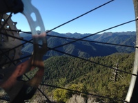
Cummins Creek Loop Trail. The descent gets right down to business with a tough rocky section before zooming across a clearing with views out over the Cummins drainage. Re-entering the forest, the trail follows a ridge down to rejoin the Cummins Creek Trail. Along the way, there are many big roots, a few rocks, lots of tight turns, and even one short steep climb.
Finish up with the smooth ride down to the car, while watching for pedestrians!
Contacts
Shared By:
Peter Carse

 Continue with onX Maps
 Continue with Facebook


 Difficult


1 Comment