Dogs Unknown

E-Bikes
Unknown

Dogs must be leashed or at heal. This is a shared biking/hiking trail, so be courteous. Plenty of parking at the top. The land is jointly controlled by the City of Richland, the BLM and a private land holding company (on the north side). Access and restrictions to the north part of the loop trail may change as construction progresses.
Description
This trail is accessible from the parking lot at the end of Glenwood Ct in Richland, or if you prefer to add more climbing, you can ride from Badger Mountain Park or the Yokes parking lots up one of the jeep track trails to the main loop.
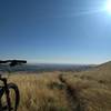
***This is a short manageable trail, with some slightly challenging sections and climbs, but expect to do 2-3 loops to feel fulfilled. It's a nice nearby option for those who want a little more variety from climbing Badger Mountain's well maintained trail at a constant climb/descent.***
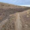
The first portion of the trail from the parking lot, left or right, is paved. I prefer to start to the right and finish coming from the left. To the right is a pavilion with some picnic tables, providing some shade and a nice place to catch your breath. up a bit farther is a bench and the end of the pavement. From there you can choose to drop down the west aspect which is a tight gravelly wide singletrack with some exposure or to the north along a rough rocky singletrack.
Headed west (down the gravel track) you'll come to a yellow gate which has berms built up on either side, travel through and press left off the main jeep trail to a fun jeep track that leads down toward some new housing. Look for a faint trail to the right and wind back over to the north side of the hill, through some construction dirt piles, for a return trip along either some more jeep track or a construction road. Ride south at the rusty water tank and pass by the yellow gate again, veering right to get back to a paved finish up to the parking lot.
The main trail meanders along with a variety of spurs that either lead down the south face of the hill to power line roads or peter out into nothing. There are a lot of boulders/rocks along the trail that can be a great playground for ambitious bikers. The trail begins and ends around an old open-mining pit, with a couple of gnarly tracks down into it from the East end. Fun to bomb down, but ride at your own risk! (Pro-tip: Park your friends at the bottom of the pit and ride up and around to the top. The descent is steep, but much more manageable than it looks from the bottom as long as you've got shocks and good brakes... you'll look like a hero!)
I haven't seen any conservation signs, and may look into developing additional portions of track to add variety and options when returning on the north side, as construction may soon swallow up the current return route.
Shared By:
Ben Singley

 Continue with onX Maps
 Continue with Facebook


 Intermediate


0 Comments