Dogs Unknown

E-Bikes
Unknown

Beware of snow and downed trees if riding before July.
Overview
This ride includes some of the ATL's finest trails linked up in a big loop of accessibility. Tons of history - tons of scenery - tons of good riding.
Need to Know
Be careful out there! There is no cell service, no close hospital, and no close bike shop - ride with a full pack and don't be a chucklehead.
Also, bring a water filter! The creek crossing at Decker before the out and back portion of the ride has the coldest, freshest snowmelt water that makes a perfect refill for the rest of the ride.
Hit up the Beaver Lodge at the end of your ride - Rusty makes a mean drink and loves chatting with out of towners.
Description
From Main St/ Middle Fork road, turn up FH207. The beginning of this ride is a bit of a doozy with a 5 mile dirt road climb up nearly 1,500 ft before reaching the Flint Creek/ Trail 067. The road winds up and up past mining operations until it reaches a flat area and branches into four other roads and the Flint Creek/Trail 067.
The Flint Creek Trail is just to the left coming up from town - depending on the time of year, the entrance might be a bit overgrown, but the singletrack is distinct and easy to follow once you find it. The singletrack gently climbs along the hill contour and then widens to a fire road after crossing a tributary to flint creek. From there, the steeper climb to the saddle begins. At the top of climb enjoy the views of the historic mining back country of Idaho before taking the plunge down to the Decker Creek Trail (Trail 081). In proper Idaho trail form, the Flint Creek descent is steep and loose with the occasional switchback. The end of the trail blends seamlessly with the Decker Creek Trail and sends you ripping up the first section of climbing.
Decker Creek is an amazing trail that winds up deep into the Idaho backcountry around rocky outcroppings, through boulder fields and forested streams, finishing high up at the very edge of the Boise National Forest and beginning of the Sawtooth National Forest. For most of the year, Decker Creek cannot be ridden all the way due to snow and down trees so it is mainly ridden as an out and back. Ride up Decker Creek as far as you can - if the trail is clear the view from the summit is truly spectacular and maximizes the downhill factor!
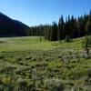
Make sure you keep your focus for the fast and snaking ride back down Decker as there are some tight turns and big rocks that could lead to big consequences in the backcountry. Once you reach the bridge again, keep your eyes peeled for the left hand turn near the junction with the Flint Creek trail. The end section of Decker Creek flows through meadows, zips between larger vegetation and finishes by rounding an exposed slide slope before the last set of steep switchbacks. Decker Creek empties out onto a loosely packed doubletrack road (Road 207), which quickly transitions into the Yuba River Road (Road 289).
Yuba River Road is fast doubletrack that goes all the way to the main road back into Atlanta, Middle Fork Road. There are plenty of small lips to jib off of all the way down so have fun trading tracks with your buddies while cruising back toward town. At the intersection with James Creek Road and Middle Fork Road, drop down to the right and take Middle Fork Road all the way back into Town. If the Beaver Creek Lodge is open, stop in for an ice cold beer and mining history lesson from the local bar keep! Then pedal back to the camping area and find the hot springs for a well deserved soak.
History & Background
Atlanta is full of history and character - check out their site before you visit!
atlantaidaho.net/Contacts
Shared By:
Z. S.

 Continue with onX Maps
 Continue with Facebook


 Difficult

 Big Smoky Trail


 Lime Creek Loop
 Idaho Trail Segment 2


0 Comments