
 Continue with onX Maps
 Sign in with Facebook


 Difficult

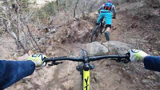
“This is a technical descent into the bottom of Bayo Canyon. ”


3.9
Miles6.2
KMSingletrack
 Difficult
Local Club: Los Alamos Singletrack Association
Land Manager: Los Alamos County, NM - Open Space and Trails
 Los Alalmos Pipe Line Guaje
16.8 mi 27.1 km • 2,894' Up 882.04 m Up • 3,019' Down 920.09 m Down
 Quemazon - Guaje Ridge - Cabra - Perimeter Loop
18.9 mi 30.4 km • 3,101' Up 945.28 m Up • 3,102' Down 945.37 m Down
Half Aspen Loop around Pajarito Ski Area
5.0 mi 8.1 km • 1,195' Up 364.09 m Up • 1,195' Down 364.18 m Down
 Dead Dog Well Loop
20.9 mi 33.6 km • 1,733' Up 528.21 m Up • 1,733' Down 528.24 m Down
 La Tierra East Loop
5.7 mi 9.2 km • 465' Up 141.77 m Up • 465' Down 141.82 m Down
 Backdoor to Atalaya Mountain Views
5.6 mi 9.1 km • 911' Up 277.54 m Up • 988' Down 301.15 m Down


0 Comments