
 Continue with onX Maps
 Sign in with Facebook


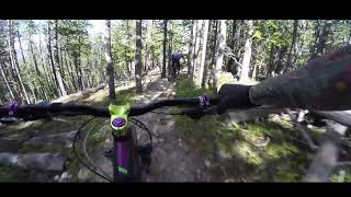
 Difficult

“A grueling climb from the parking lot that ends at Peaks Trail and Miners Creek Trail. ”


13.9
Miles22.4
KMSingletrack
 Difficult
Local Club: Summit County Mountain Bike Alliance
Land Manager: USFS - White River National Forest Office
 River Trail
3.1 mi 4.9 km • 86' Up 26.11 m Up • 137' Down 41.76 m Down


 Red Trail
2.9 mi 4.7 km • 90' Up 27.33 m Up • 797' Down 243.05 m Down
 Rock Island to Galena Ditch
21.9 mi 35.3 km • 2,392' Up 729.13 m Up • 2,396' Down 730.44 m Down
Frisco Peninsula Long Loop
11.4 mi 18.4 km • 785' Up 239.32 m Up • 784' Down 238.94 m Down
Breckenridge to Como
22.6 mi 36.4 km • 2,399' Up 731.27 m Up • 2,257' Down 688.05 m Down
Brecken…, CO
 Breck 100: Loop 2
34.8 mi 56.0 km • 4,580' Up 1396.1 m Up • 4,583' Down 1397.05 m Down


 All Clear


2 Comments