Dogs Unknown

E-Bikes
Unknown
Overview
Welcome to
Wilkesbermo.
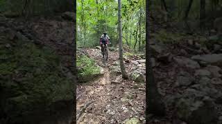
Ride any trail at Kerr Scott and it wont take you long to figure out why the area has acquired the nickname that typifies its trail system; hundreds of bermed and banked turns await you on a journey thats been compared to a 30 mile roller coaster ride!
Kerr Scott has three main trail systems:
Dark Mountain,
Overmountain Victory Trail, and
Warrior Creek, and shorter trails either looping or connecting to those main veins. Most riders park at any of the main trailheads for shorter rides, or set up a shuttle to incorporate more trails (like the full Epic route described below). All three trail systems have their own character, and riding the Epic route will take you through the best of each.
The Kerr Scott trail system lies between the Brushy Mountains and the Blue Ridge in the Yadkin Valley, a very historic corridor that has previously served as a path for Daniel Boone, the Overmountain Men and plenty of moonshiners.
Need to Know
The Kerr Scott Visitors Assistance Center is the place for info. Here, youll find trail maps, camping and day-use information, and more. Public restrooms are available during the center hours: 8AM - 4:30PM.
Campgrounds at Kerr Scott are right next to trail crossings, so route planning can can include ride-in/ride-out options.
The trails close occasionally for bad weather. If the forecast looks sketchy, head to the
USACE facebook page for the latest updates.
There is free parking at all trail locations, but fees may apply at the
Warrior Creek Trail entrance lot since it is considered a day use area. Free Parking for Warrior is available at the back parking lot off of Boomer-Ferguson Road.
Description
The Kerr Scott Epic route begins on the
Fish Dam Creek Trail below the dam. This location can also be accessed from the Visitor Center with a short ride on pavement. Continue past the Yadkin Greenway, which forks to the right at a bridge. Continue on Fish Dam Creek, up a few switchbacks and over the top. Youll pass an overlook and connect with the
Dark Mountain entrance trail.
Dark Mountain, the first of Kerr Scotts purpose-built MTB trails, has some of the most technical riding at the lake. The route through Dark has many intersecting trails, but it is well-marked, with numbered sections and two color-coded routes that link it all together. Follow the blue arrows which will include two sustained descents on
The Snake and
Lake Loop and solid climbs to go along with them. The MTB Project mobile app can also help keep you on track. The last section of
Dark Mountain includes a thrilling finale with banked turns and alternate-line jumps. Once out of the woods, Follow the gravel trail past the parking lot and up the steep paved road. Traverse the dam, take in the view, and take the first right toward the Visitors Center. Here, take a break if youd like, or continue right away to the
Overmountain Victory Trail.
The OVT is clearly marked from the Visitor Center lot. It has some steep sections but the climbs/descents are short. 1.5 mi into OVT, is the intersection with
Shiner's Run. After this loop, turn right on OVT again. You'll encounter two road crossings, which are great regroup points. After the second, turn right on
Horton's Hollar, one of the newest of all the trails at the lake. The Hollar is tight and twisty on the first half compared to Shiners and OVT, but has nearly 100 bermed turns. After finishing this trail, turn left on OVT again for the last section before Bandits Roost.
After Bandits Roost Campground it will be time for the not-so-fun part of the ride, 3 miles of pavement. Take a left on Jess Walsh Road, then a Right on NC 268, a moderately traveled two-lane highway. After 2 miles on 268 youll see a bridge and the Blood Creek Overlook on the right. Stop here if youd like to get a good view of
Warrior Creek from the Overlook. After the bridge, there's a short climb; take the first right, and continue down the hill to the gatehouse. A left here will take you to the WC parking area. If setting up a shuttle to here, this would be a good spot for a vehicle. Youre not finished riding yet though-youve arrived at
Warrior Creek, the gem of all Kerr Scotts Trails.
Go straight after the stop sign at the
Warrior Creek gatehouse and look to the left for the hard-to-spot
OVT at Warrior Creek Trailhead. This Epic route continues here and the final 13 miles of amazing singletrack does also.
Once on the trail again, youll cross a bridge and end up below the parking area. Continue straight until the trail crosses the road and take are RIGHT on the
Warrior Creek Trail (OVT turns left).
Warrior Creek provides a nice finale to the Epic route, and is the most recent trail to be constructed on the this route. Youll find that many of the turns here are effortless. With banked turns on every corner, enjoy the flow and lay off the brakes!
Following the contours of the Reservoir and the Yadkin River, the trail completely encircles the campground area. There will be road crossings near camping areas. You can find water at the campgrounds and bath houses (April - Oct).
About 10 miles into
Warrior Creek, after a short climb to a rocky ridge, youll encounter Tater Tot, the first of two rock gardens on the loop. Shortly after, youll see the trailhead to
Headwaters an advanced loop that contains very technical, rocky terrain. Stay left here, climb up and cross a 2-track road, and descend the longer rock garden shortly after. After crossing the final two campground roads, youll intersect again with the OVT. Take a left on this and continue to either of the parking areas, both within 2 miles from this turn.
Done!
History & Background
The Brushy Mountain Cyclists Club (BMCC) builds and maintains all of the trails at Kerr Scott. The BMCCs relationship with the US Army Corps of Engineers is an amazing model of partnership. The MOU (est. in 2002) was the first of its kind in the country between a club and USACE. BMCC has built over 40 miles of trail at Kerr Scott since 2002. It all got started in that year with Dark Mountain, and was orchestrated by a visit from IMBA Trail Care Crew. Under the leadership and zeal of BMCC Trail Boss, Jim Horton, and thousands of volunteer hours, trail mileage continues to grow. Also growing is its significance as national destination for mountain biking. The trails hold three national designations: Dark Mountain was named a National Recreation Trail in 2005, The OVT has been a part of the Overmountain Victory National Historic Trail System since its completion in 2006, and the entire Kerr Scott Trails system was named an IMBA Epic in 2011.
Contacts
Shared By:
Paul Stahlschmidt
with improvements
by Liz DiNatale

 Continue with onX Maps
 Sign in with Facebook


 Intermediate

 4.4 (56)


1 Comment