
 Continue with onX Maps
 Continue with Facebook


 Intermediate

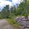
“Doubletrack that begins as gravel road and becomes increasingly remote upon connecting to Flat Creek Trail. ”


1.1
Miles1.7
KMDoubletrack
 Intermediate
Land Manager: USFS - Nantahala National Forest Office
 Panthertown Loop
12.0 mi 19.3 km • 1,523' Up 464.17 m Up • 1,515' Down 461.9 m Down


 Sycamore Cycles Swank 65
36.3 mi 58.5 km • 5,512' Up 1679.98 m Up • 5,512' Down 1679.96 m Down
Brevard, NC
Pisgah Stage Race - Stage 3
31.4 mi 50.5 km • 5,727' Up 1745.44 m Up • 5,728' Down 1745.87 m Down
Brevard, NC
Pisgah 55.5K MTB Race
38.4 mi 61.8 km • 7,798' Up 2376.79 m Up • 7,800' Down 2377.3 m Down
Brevard, NC
Clawhammer Crawl
35.4 mi 56.9 km • 5,461' Up 1664.41 m Up • 5,517' Down 1681.61 m Down
Brevard, NC
Avery Creek to Bennett Gap Loop
15.7 mi 25.2 km • 3,013' Up 918.33 m Up • 3,017' Down 919.45 m Down
Brevard, NC


0 Comments