Dogs Off-leash

E-Bikes
Not Allowed

As a reminder, please be mindful of other trail users and yield to uphill traffic.
Description
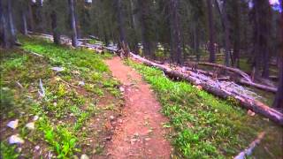
Graysill is one of my all time favorite trails and a favorite to the area as someone who is gravity orientated and seeks Rocky and rooty tech tailored to bikers. Although there are some others in the area that have similar features, Graysill is a trail that rides as if built by a biker for bikers. It just has that feeling. It is worth the effort to get to the trail. The first half of the trail is fairly high speed and has ripping turns, great dirt, and a good mix of root littered sections. Once you cross the road into the second half, the quantity of rocks increases and the fun keeps going up. Immediately, there is some rhythm to the rough. The whole rest of the trail is intermittent root and rock sections, some off camber, high lines, all the things that make you smile when seeking trails like such. It is finished up by a larger and chunkier rock section that flows into some faster and smoother turns eventually bumping into Cascade Creek and a beautiful view of the valley you sit in.
This trail is a great descent that connects the Colorado Trail to Cascade Creek trail (W). Stay on the west side until crossing Cascade Creek at the end of it. Do not ride the east side unless you are seeking a lot more ups and downs.
A popular loop is to start at Coal Bank Pass, ride
Pass Creek to Engineer Mountain Trail, head north (right) and either go left at White Creek or continue on EMT and go left on the Colorado Trail; eventually you'll hang a left onto Graysill and then connect to Cascade to end at the highway. Both options involve a big day but are worth it for this sweet descent at the end!
Another popular route is to start at CT on Molas Pass and connect that to the fin descent of Rolling Pass. Once there, stay on CT Rolling Pass until you get to Graysill.
Local trail builders have put a lot of work into this trail the past few years and the results are worth it!
Contacts
Shared By:
Storm Perrella
with improvements
by Silverton Singletrack Society
and 1 other

 Continue with onX Maps
 Sign in with Facebook


 Difficult

 4.7 (7)


0 Comments