
 Continue with onX Maps
 Continue with Facebook


 Difficult

“A short, scenic, technical loop around the petroglyph site. ”


2.0
Miles3.2
KMSingletrack
 Difficult
Land Manager: BLM New Mexico - Roswell Field Office
 12 Hours in the Wild West
11.9 mi 19.2 km • 1,260' Up 384.09 m Up • 1,216' Down 370.57 m Down

 12 Hours in the Wild West: 6 Hour Race Loop
6.8 mi 11.0 km • 784' Up 238.98 m Up • 737' Down 224.65 m Down
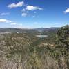
Ruidoso, NM
Grindstone Lake Trail Extended
11.7 mi 18.9 km • 1,158' Up 352.93 m Up • 1,163' Down 354.5 m Down
 Ruidoso, NM


0 Comments