Use onX Backcountry to explore the terrain in 3D, view recent satellite imagery, and more.
Now available in onX Backcountry Mobile apps!
For more information see this post.
“This is a long but not particularly exciting connector that mostly follows roads.
”
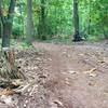
This trail connects the Papenvoortse Heide in Nuenen with the Vresselse Bos in Sint Oedenrode. The markings are poor, and even missing entirely at some vital points. It's recommended you take careful study of the map, download a track to your GPS, or pay attention to the MTB Project mobile app to stay on track.
Most of the connection trail runs on quiet local roads. There is only a small part where the trail goes over a somewhat larger and busier local road.
Moderately steep. Uneven terrain with small rocks or roots.
Sizable rocks & roots. Steep sections.
Steep. Some technical terrain and limited alternate lines.
Very steep. Technical terrain with no alternate lines.
Difficulty Rating
Average from 1 vote:
Easy
Your Rating
Virtual Tour of Papenvoortse Heide to Vresselse Bos Connector
We use cookies to improve your browsing experience, to show you
personalized content, and for statistical purposes. By continuing
to navigate our website, you accept our use of cookies. Read our
Privacy Policy to learn more.

 Continue with onX Maps
 Continue with Facebook


 Easy
Easy


0 Comments