
 Continue with onX Maps
 Continue with Facebook


 Easy/Intermediate

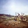
“Live on the edge! Well maybe not the very edge but close enough to check out the great views. ”


1.7
Miles2.7
KMDoubletrack
 Easy/Intermediate
Local Club: Boise Area Mountain Bike Association
Land Manager: BLM Idaho - Boise District Office
 Homestead to Highland Valley
10.2 mi 16.4 km • 1,620' Up 493.65 m Up • 1,657' Down 504.93 m Down


 Shane's Loop
8.3 mi 13.4 km • 926' Up 282.32 m Up • 922' Down 281.11 m Down
Hulls Gulch Loop
7.9 mi 12.7 km • 869' Up 264.74 m Up • 869' Down 264.74 m Down
Boise, ID
Sanford and Son
18.4 mi 29.6 km • 2,521' Up 768.45 m Up • 2,518' Down 767.39 m Down
Double D
17.7 mi 28.5 km • 2,596' Up 791.12 m Up • 2,594' Down 790.71 m Down
Boise, ID
 BB Bomber
27.4 mi 44.2 km • 2,060' Up 627.92 m Up • 4,923' Down 1500.6 m Down
Boise, ID


0 Comments