
 Continue with onX Maps
 Continue with Facebook


 Intermediate

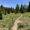
“The Transfer Road Section of the Tabeguache Trail climbs to Uncompahgre Plateau crest. ”


8.9
Miles14.3
KMDoubletrack
 Intermediate
Local Club: Colorado Plateau Mountain Bike Trail Association
Land Manager: USFS - Grand Mesa, Uncompahgre, and Gunnison Nat. Forests
 Buck and Aspen Combo
17.6 mi 28.2 km • 1,858' Up 566.19 m Up • 1,853' Down 564.81 m Down


 Buzzard Gulch Loop
11.6 mi 18.7 km • 1,050' Up 320.17 m Up • 1,058' Down 322.39 m Down
Lower Spring Creek Loop
15.0 mi 24.1 km • 1,709' Up 520.81 m Up • 1,726' Down 526.04 m Down
Montrose, CO
47 Trail (403)
9.8 mi 15.8 km • 837' Up 255.03 m Up • 1,294' Down 394.48 m Down
Eagle Spikes Enduro Loop
7.1 mi 11.4 km • 1,438' Up 438.3 m Up • 1,458' Down 444.42 m Down
 Sunset Rocks
6.7 mi 10.8 km • 1,048' Up 319.53 m Up • 1,063' Down 324.03 m Down


0 Comments