
 Continue with onX Maps
 Sign in with Facebook


 Intermediate/Difficult

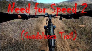
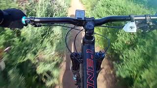
“The Guadalasca Trail is a great option for technical singletrack downhill fun. ”


4.0
Miles6.4
KMSingletrack
 Intermediate/Difficult
Local Club: Concerned Off-Road Bicyclists Association - CORBA
Land Manager: California State Parks - Point Mugu
 Backbone Trail: Yerba Buena Section
4.7 mi 7.5 km • 483' Up 147.17 m Up • 443' Down 134.91 m Down

 Thousan…, CA
Dos Vientos Tour
Thousan…, CA
Dos Vientos Tour
12.2 mi 19.7 km • 1,261' Up 384.48 m Up • 1,261' Down 384.3 m Down
 Backbone Trail: Zuma Ridge to Encincal
2.4 mi 3.9 km • 345' Up 105.29 m Up • 685' Down 208.66 m Down
Triunfo Open Space Loop
9.2 mi 14.8 km • 1,445' Up 440.51 m Up • 1,442' Down 439.39 m Down
Wildwood Loop
9.1 mi 14.6 km • 1,226' Up 373.61 m Up • 1,237' Down 376.91 m Down
New Millennium Trail + Las Virgenes Downhill
17.2 mi 27.7 km • 2,558' Up 779.81 m Up • 2,568' Down 782.63 m Down


0 Comments